Translated automatically by AI from the Italian original.
ROME – High pressure is moving towards the British Isles, opening the way for cold air currents from the Balkans and north-east. Italy is thus entering a phase of marked bad weather set to characterise Sunday 1 and Monday 2 November 2026, with heavy downpours, gusty winds, a general temperature plunge and the first significant snowfalls along the central Apennine ridge.
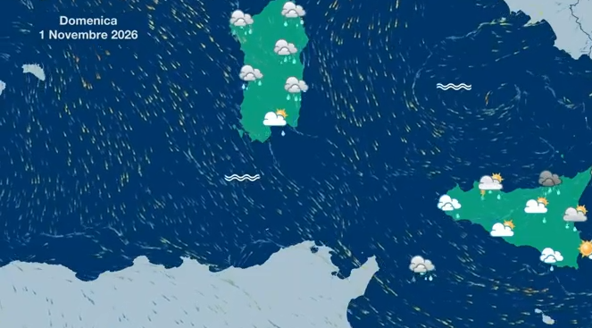
Forecast for Sunday 1 November: storms in the south and Sicily
The worsening weather directly affects the regions of central and southern Italy and Sicily (with the exception of Tuscany and Umbria), extending as far as Romagna and scattered sectors of north-west Italy:
- North: Mostly sunny but with banks of fog and dense mist in the Po Valley during the coldest hours. Light rain in the morning in lowland Romagna.
- Centre and Sardinia: Cloudy skies with downpours and storms in Marche and Abruzzo, spreading to lower Lazio. Phenomena easing in the evening in inland areas.
- South and Sicily: Increased instability with scattered downpours and storms on the Adriatic and Ionian sectors and on the major islands (particularly intense in Puglia). Rain also on the Tyrrhenian areas but absorbing in the evening.
- Temperatures: Maximum temperatures falling across most of the northern regions, in Marche, Abruzzo, Puglia, Calabria and northern Sicily.
Monday 2 November: snow in the Apennines and strong winds
On Monday the cold impulse will reach its peak, bringing widespread precipitation and exceptional snowfalls on the central mountain ranges:
- Snow in the Apennines: Snowfall expected on the Abruzzo Apennines and on the mountains of Lazio and Molise, with snow levels initially between 1,100 and 1,300 metres overnight, gradually rising to 1,500–1,600 metres in the morning.
- Widespread bad weather in the south: Persistent downpours and storms in Basilicata, Puglia and Sicily (especially in the southern and eastern sectors), partially easing in the evening in northern Campania.
- Winds and seas: Strong winds from the north-eastern quadrants with Bora gusts on the Adriatic and grecale on the Tyrrhenian and Apennines. Seas from very rough to rough, particularly the Strait of Sicily, the southern Tyrrhenian and the Ionian.
Outlook for the following days
From Tuesday 3 November there will be a gradual improvement in the north and the central Tyrrhenian regions, while residual showers persist in the south and on the Sicilian Tyrrhenian sectors. By Wednesday 4 November the precipitation will become more isolated and confined mainly to southern Calabria, the Puglia coast and the eastern sectors of the major islands.